Pixel is an NGO founded by scientists with a strong analytical background and extensive experience in environmental research. Our mission is to tackle pressing environmental issues using advanced quantitative tools, remote sensing, and artificial intelligence, generating quantitative data to enrich the public discussion.
Remote sensing
We specialize in remote sensing data, including optical imagery, Synthetic Aperture Radar (SAR), and LIDAR. Our team has extensive expertise using these datasets to address critical environmental challenges.
Data Science & AI
We apply advanced data science methods and state-of-the-art AI techniques to analyze large and complex environmental datasets.
Education
We believe that knowledge is most powerful when it’s shared. Our team develops clear, engaging educational resources and public outreach programs to make complex environmental and scientific concepts accessible to everyone.
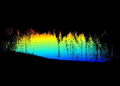
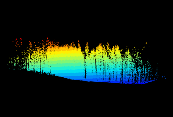
Estimating forest biomass through remote sensing is crucial in the context of carbon sequestration, as it is the only way to systematically and periodically quantify the amount of carbon stored in forest ecosystems. Forests act as carbon sinks by absorbing carbon dioxide (CO₂) from the atmosphere during photosynthesis and storing it in their biomass.
Among the most widely used satellite systems, ranked in terms of error in aboveground biomass estimation (AGBD), are lidar, SAR, and optical sensors (each with its own challenges). The development of accurate estimation algorithms is an open issue. However, estimates from these instruments are regularly used to monitor deforestation, forest degradation, and natural regeneration processes, as input for decision-making in conservation, reforestation, and sustainable management policies. These data are essential for meeting international climate-related commitments, such as the Paris Agreement and REDD+ (Reducing Emissions from Deforestation and Forest Degradation) mechanisms.
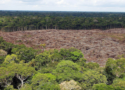
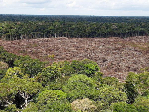
Deforestation poses a significant threat to natural ecosystems, particularly in Argentina’s Chaco region—one of the world’s most rapidly changing forest areas. This study focuses on the detection of sudden deforestation events, where forest cover is rapidly removed within a few months. Monitoring such changes across vast areas requires the use of satellite-based vegetation indices, such as EVI and NDVI from MODIS. However, accurately identifying deforestation events is challenging due to seasonal variability, sensor noise, data gaps, and algorithmic inconsistencies. These factors can obscure true deforestation signals or generate false positives. To address these issues, a robust detection approach must explicitly model time-series dynamics—capturing trends, seasonality, and uncertainty—to reliably distinguish genuine deforestation breakpoints from natural variation and noise. In this paper, three models for the detection of breakpoints in EVI time series were proposed: a simple z-score anomaly detector, and two fully Bayesian models; one temporally uncorrelated and one fully correlated. Results indicate that the Bayesian schemes significantly improve over the naive approach (zscore: AUC=0.921, F1-score=0.870, Bayes: AUC=0.959, F1-score=0.925), for a reasonable cost in computing time (x1000).
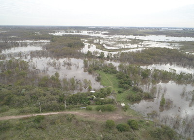
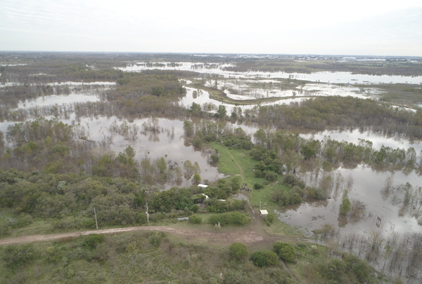
Following the PROSAT II call from the National Commission for Space Activities (CONAE), a system was developed using active microwave polarimetric satellite information from the Argentine SAOCOM Mission, together with other optical and radar satellite data, for monitoring wetlands in Argentina (in line with the use of satellite information for wetland inventory programs). Work was carried out in pilot wetland landscape units: the Ramsar Site in the Upper Delta (Entre Ríos Province), Concepción del Uruguay (Entre Ríos Province), and Bajo de los Saladillos (Santa Fe Province). The first objective was to develop a catalog of backscatter coefficients (active microwave, C and L bands) and spectral responses (visible and reflective infrared) associated with the wetland types in the study areas.
The catalog is an interactive dashboard that displays graphs for each wetland type, allowing users to view spectral signatures or characteristic backscatter (mean values and deviation or range of variation) for a selected period, as well as the temporal dynamics of backscatter or synthetic indices derived from optical satellite data. The dashboard was designed with two modalities: a) exploratory, in which each user can obtain graphs by freely filtering by scene type, date, and wetland type; b) guided, in which pre-built graphs are accessed, accompanied by an interpretation made by the consultants (for example, differences between dry and wet periods, or analysis of differences between wetland types). It is useful for managers involved in wetland mapping, as it provides a summary and interpretation of SAR and optical information.
Francisco (he/him) is a physicist and a leading researcher at CONICET, specializing in advanced quantitative remote sensing, electromagnetic scattering models, Bayesian inference, and deep learning techniques. With over two decades of experience in satellite-based time-series analysis, he has contributed significantly to major Argentine space missions (e.g., SAOCOM, SAC-D/Aquarius), focusing on the extraction of environmental parameters from SAR and multi-sensor satellite imagery.
Natalia Morandeira, PhD
Vice President
Natalia (she/her) serves as Adjunct Investigator, bringing deep expertise in wetland and landscape ecology, biodiversity monitoring, and satellite-based remote sensing using optical, SAR, and polarimetric data. As a researcher at the Argentina’s National Research Council (CONICET), she has coordinated several national and international projects, emphasizing ecosystem monitoring and environmental risk assessment in complex habitats, including wetland systems of the Paraná River floodplain and coastal environments along Buenos Aires Province. She has been the PI or Co-PI on research agreements with Space Agencies (from Argentina, Japan, Canada, and Italia), involving the development of applications for wetland monitoring using SAR or PolSAR data from SAOCOM, ALOS/PALSAR-2 and RADARSAT-2 and CosmoSkyMed data. Besides, she is currently teaching the Ecology course at the University of San Martín (UNSAM) and collaborates with the Landscape Ecology course at the University of Buenos Aires (UBA).
Esteban Roitberg, PhD
Director
Esteban (he/him) contributes strong expertise in data science, specializing in the application of machine learning and deep learning techniques to environmental challenges. He also has experience in the financial sector and in applying artificial intelligence to healthcare problems. His Ph.D. research focused on near-real-time deforestation detection using optical remote sensing combined with advanced machine learning models. His current roles as Senior Data Scientist and consultant emphasize methodological rigor in data analysis and the practical application of machine learning approaches. As an Adjunct Professor in the Data Science program at UNSAM, he designed and launched the university’s first Introduction to Machine Learning course, creating the syllabus, lectures, and assignments from scratch—and is now doing the same for the Advanced Machine Learning course.
Francisco González Bianco
Collaborator
Francisco (he/him) is an Environmental Engineering student, contributes technical expertise in environmental engineering, machine learning, and data management. His experience includes developing open-source monitoring tools and computational pipelines, with a particular focus on data quality and system reliability for environmental assessments and emission calculations. He also has a strong background in water and wastewater quality, management, and treatment, including the design and evaluation of treatment systems, regulatory compliance, and the integration of data-driven approaches to improve decision-making in water resource management. He is currently teaching the Introduction to Machine Learning Course at UNSAM.
Javier Arellana
Collaborator
Javier (he/him), M.Sc. in Physics and Ph.D. candidate at UBA, specializing in soil moisture estimation using SAR and GNSS data. Workplace: Institute of Astronomy and Space Physics, Remote Sensing Group. Skilled in physically based modeling, Bayesian inference, and advanced satellite image processing. Author of peer-reviewed publications and active contributor to scientific conferences. Possesses solid university teaching experience, serves as an invited reviewer for international journals, and engages in collaborative multidisciplinary research aimed at advancing Earth observation methods and applications.
Featured Publications
“Enhanced CyGNSS Soil Moisture Retrieval Validated by In Situ Data in Argentina's Pampas”
F. Grings, A. Leszczuk, E. Hildt, D. Lorán, J. Arellana, et. al. Journal of Applied Remote Sensing, vol. 19, Issue 2, Art no. 024502, 2025 https://doi.org/10.1109/JSTARS.2025.3526445
“Validation of GEDI above ground biomass product over Pinus sp. plantations in Argentina”
J. Arellana, F. Grings and M. Franco IEEE Journal of Selected Topics in Applied Earth Observations and Remote Sensing, vol. 18, pp. 3728-3734, 2025 https://doi.org/10.1117/1.JRS.19.024502
“Validation of SAOCOM-Estimated Soil Dielectric Constant Using a Bayesian Inference Scheme in Agricultural Fields”
J. Arellana, M. Franco and F. Grings IEEE Biennial Congress of Argentina (ARGENCON), San Nicolás de los Arroyos, Argentina, pp. 952-954, 2024 http://dx.doi.org/10.1109/ARGENCON62399.2024.10735952
“Using SAOCOM Data and Bayesian Inference to Estimate Soil Dielectric Constant in Agricultural Soils”
J. Arellana, M. Franco and F. Grings IEEE Geoscience and Remote Sensing Letters, vol.20, pp.1-5, 2023 https://doi.org/10.1109/LGRS.2023.3296094
“Estimation of Soil Dielectric Constant Using GNSS Reflectometry and Interference Pattern Method”
E. N. Gomes, J. Arellana, et al. Anales AFA Vol. 30 Nro. 4, 2020 http://dx.doi.org/10.31527/analesafa.2019.30.4.90
Dr. Francisco Grings
Presidente
Francisco (él) es físico e investigador principal del CONICET, especializado en teledetección cuantitativa avanzada, modelos de dispersión electromagnética, inferencia bayesiana y técnicas de aprendizaje profundo. Con más de dos décadas de experiencia en análisis de series temporales satelitales, ha contribuido significativamente a importantes misiones espaciales argentinas (p. ej., SAOCOM, SAC-D/Aquarius), centrándose en la extracción de parámetros ambientales a partir de imágenes satelitales SAR y multisensor.
Dra. Natalia Morandeira
Vicepresidenta
Natalia (ella) se desempeña como Investigadora Adjunta, con amplia experiencia en ecología de humedales y paisajes, monitoreo de biodiversidad y teledetección satelital mediante datos ópticos, SAR y polarimétricos. Como investigadora del Consejo Nacional de Investigaciones Científicas y Técnicas (CONICET), ha coordinado diversos proyectos nacionales e internacionales, con énfasis en el monitoreo de ecosistemas y la evaluación de riesgos ambientales en hábitats complejos, incluyendo los sistemas de humedales de la llanura aluvial del río Paraná y los ambientes costeros de la provincia de Buenos Aires. Ha sido Investigadora Principal o Co-Investigadora Principal en convenios de investigación con Agencias Espaciales (de Argentina, Japón, Canadá e Italia), involucrando el desarrollo de aplicaciones para el monitoreo de humedales utilizando datos SAR o PolSAR de SAOCOM, ALOS/PALSAR-2 y RADARSAT-2, y datos de CosmoSkyMed. Además, actualmente imparte la cátedra de Ecología en la Universidad de San Martín (UNSAM) y colabora con la cátedra de Ecología del Paisaje en la Universidad de Buenos Aires (UBA).
Dr. Esteban Roitberg
Director
Esteban (él) aporta una sólida experiencia en ciencia de datos, especializándose en la aplicación de técnicas de aprendizaje automático y aprendizaje profundo a desafíos ambientales. También cuenta con experiencia en el sector financiero y en la aplicación de inteligencia artificial a problemas de salud. Su investigación de doctorado se centró en la detección de deforestación casi en tiempo real mediante teledetección óptica combinada con modelos avanzados de aprendizaje automático. Sus funciones actuales como Científico de Datos Sénior y consultor se centran en el rigor metodológico en el análisis de datos y la aplicación práctica de enfoques de aprendizaje automático. Como Profesor Adjunto del programa de Ciencias de Datos de la UNSAM, diseñó y puso en marcha el primer curso de Introducción al Aprendizaje Automático de la universidad, creando el programa de estudios, las clases y las tareas desde cero, y ahora está haciendo lo mismo para el curso de Aprendizaje Automático Avanzado.
Francisco González Bianco
Colaborador
Francisco (él) es estudiante de Ingeniería Ambiental, aporta experiencia técnica en ingeniería ambiental, aprendizaje automático y gestión de datos. Su experiencia incluye el desarrollo de herramientas de monitoreo de código abierto y canales computacionales, con especial énfasis en la calidad de los datos y la confiabilidad de los sistemas para evaluaciones ambientales y cálculos de emisiones. También cuenta con una sólida formación en calidad, gestión y tratamiento de agua y aguas residuales, incluyendo el diseño y la evaluación de sistemas de tratamiento, el cumplimiento normativo y la integración de enfoques basados en datos para mejorar la toma de decisiones en la gestión de recursos hídricos. Actualmente imparte el Curso de Introducción al Aprendizaje Automático en la UNSAM.
Javier Arellana
Colaborador
Javier (él) es Licenciado Física, doctorando en la UBA especializado en la estimación de humedad del suelo mediante datos SAR y GNSS. Lugar de trabajo: Instituto de Astronomía y Física del Espacio, Grupo de Teledetección. Experiencia en modelado físico, inferencia bayesiana y procesamiento avanzado de imágenes satelitales. Autor de publicaciones revisadas por pares y participante activo en congresos científicos. Amplia trayectoria docente universitaria, revisor invitado en revistas internacionales y colaborador en investigación multidisciplinaria orientada al desarrollo de métodos y aplicaciones en observación de la Tierra.
Featured Publications
“Enhanced CyGNSS Soil Moisture Retrieval Validated by In Situ Data in Argentina's Pampas”
F. Grings, A. Leszczuk, E. Hildt, D. Lorán, J. Arellana, et. al. Journal of Applied Remote Sensing, vol. 19, Issue 2, Art no. 024502, 2025 https://doi.org/10.1109/JSTARS.2025.3526445
“Validation of GEDI above ground biomass product over Pinus sp. plantations in Argentina”
J. Arellana, F. Grings and M. Franco IEEE Journal of Selected Topics in Applied Earth Observations and Remote Sensing, vol. 18, pp. 3728-3734, 2025 https://doi.org/10.1117/1.JRS.19.024502
“Validation of SAOCOM-Estimated Soil Dielectric Constant Using a Bayesian Inference Scheme in Agricultural Fields”
J. Arellana, M. Franco and F. Grings IEEE Biennial Congress of Argentina (ARGENCON), San Nicolás de los Arroyos, Argentina, pp. 952-954, 2024 http://dx.doi.org/10.1109/ARGENCON62399.2024.10735952
“Using SAOCOM Data and Bayesian Inference to Estimate Soil Dielectric Constant in Agricultural Soils”
J. Arellana, M. Franco and F. Grings IEEE Geoscience and Remote Sensing Letters, vol.20, pp.1-5, 2023 https://doi.org/10.1109/LGRS.2023.3296094
“Estimation of Soil Dielectric Constant Using GNSS Reflectometry and Interference Pattern Method”
E. N. Gomes, J. Arellana, et al. Anales AFA Vol. 30 Nro. 4, 2020 http://dx.doi.org/10.31527/analesafa.2019.30.4.90